

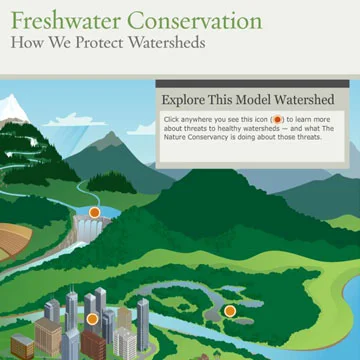
A river's watershed, is the area that contains all the water that will eventually flow to a common outlet (check out this watershed interactive map). Why are they so important? Watersheds provide critical habitats to numerous species, but they also provide a huge network of natural infrastructure (e.g. forests, wetlands, lakes, etc.) that provide clean water to the world's cities. While the science of watershed protection has been around for many decades, it has not been widely practiced. However, by preserving, restoring, and protecting upstream watersheds, cities can improve and maintain healthy drinking water without having to pay for expensive water treatment plants – as well as improve the upstream environment. As we will point out, watershed protection has vast economic and ecological benefits.
Problems
Historically, land adjacent to rivers and lakes in upper reaches of the watershed have been popular sites for deforestation, agriculture and irrigation, and dams, which have severe implications to water quality and ecosystems.
Challenges
While many modifications have altered the watershed landscapes that directly and indirectly cause lower water quality, another challenge will be changing people's perspectives to think differently about daily water usage.
Solutions
Rivers are the arteries of our planet. They provide a steady flow of clean, fresh water is an essential element for vast ecosystems and the health and survival of billions of people. Protecting our water at the source (i.e. the watershed) often costs less and is more efficient than treating polluted water (Nature Conservancy).
Many solutions have been around for decades, yet new innovations and evolving regulations have allowed for an increased ability to collect and afford the valuable data that is required to efficiently and effectively implement watershed protection.
New York City: An International Example
Cities around the world have invested and dramatically benefited from watershed protection. New York City (NYC), and it’s 9 million residence, receive their water from a 2,000 square mile watershed, and today NYC is one of only 5 large U.S. cities that do not require water filtration. This is due to proactive watershed protection program. In the 1990’s, due to the Safe Drinking Water Act, NYC either had to either build a surface-water filtration systems, or prove that they can protect their water source. The cost of such a facility was estimated at $6 billion and an additional $300 million per year to operate (in 1990 dollars). Alternatively, it was estimated that $1.5 billion would be required to preserve and protect the watershed. Today, this watershed protection is an international example of the ecological and economical benefits that can be achieved from watershed protection. To learn more, click the NYC case study below or visit their page here.
Data: You cannot manage what you don't measure.

To achieve the best results, watershed protection needs to target the biggest contributors to poor water quality and areas tied to lowering water quantity. To target these areas requires a lot of data since the majority of contributions are non-point source pollution. Data like:
- spatial water quality mapping,
- several water quality sensors linked to cloud data sharing,
- frequent and low cost aerial imagery,
- current and affordable topographic maps,
- and land ownership parcels.
Combining these data, problem areas can be determined and local land owners can be approached for collaboration. Previously, such aerial imagery and topographic data required expensive manned aircraft and sensors, however, today new methods of remote sensing and Unmanned Aircraft Systems (UAS, or UAV, or drones) are providing high resolution datasets at more affordable costs than were possible by previous platforms. The benefits of such systems enable watershed protection to capture fast and highly accurate datasets, that can be quickly implemented into analysis, as well as future monitoring and ongoing assessments.
Drones: Fast, Efficient, and Affordable
Drones are currently being equipped with GPS, tools, and various sensors. Of most interest, are spatial water quality sampling and tree planting. Historically, water quality data has been collected manually in the field and at infrequent intervals in time. Now, Uviation is developing an autonomous drone that will travel with the river currents and document several water quality parameters. With each water quality measurement being geo-located with GPS, maps of water quality can be developed to help identify locations along rivers where point source and non-point source pollution is being introduced.
Through innovative methods and creative thinking, drones are now being developed that can plant trees. Historically, planting trees has been done by seed dispersal and by hand. While seed dispersal is much faster application, survival rates are single digits, and hand planting is very slow and labor intensive but achieves up to a 90% survival rate. Using drones and innovative planting tools, BioCarbon Engineering is hoping to achieve planting rates 10 times faster than hand planting while achieving high survival rates.
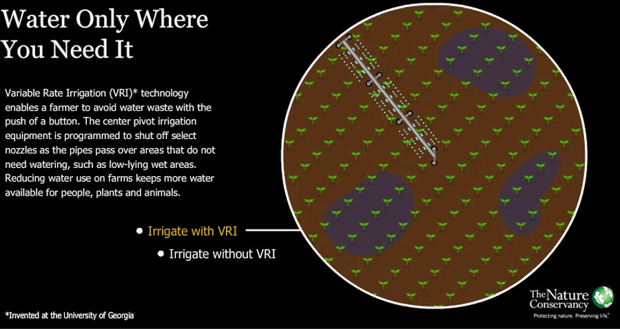
Drones are currently being utilized and developed to better inform agriculture in the most efficient application of water, fertilizers, pesticides, and identifying where ground water runoff is occurring, and showing great potential to not only minimize their pollution, but at the same time reduce costs as well as increase crop yields. Using drones for crop dusting, offers significant benefits as well, as more frequent application to areas that are needed can avoid spraying the whole field with tractors or manned aircraft crop dusting. Not only does this make the application more targeted and lower the chances of over application, but it vastly reduces the emissions, as small drones emit less than tractors and manned aircraft.
Videos To Watch
Articles And Links
Case Studies
Video thanks to the Watershed Agricultural Council.